

Map Settings
Configuration options for the monitoring map: map type, display, stops, POIs and vehicle labels.
In the map settings you can configure which information is displayed on the map and how the map behaves. Settings are per user and are saved automatically.
Opening Settings
Click the settings icon Map settings in the upper right corner of the map to open the settings panel. Changes take effect immediately. Click the X to close the panel again.
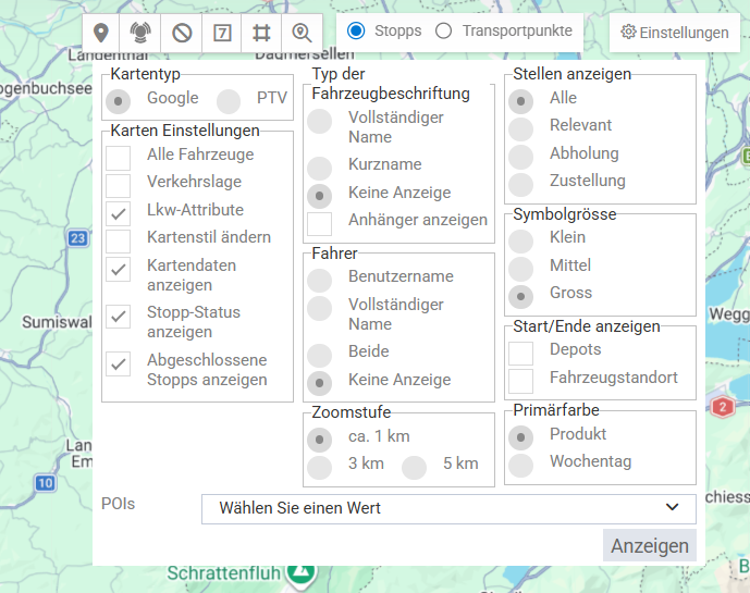
Map Type
Under Map and geolocalization type (web) you choose between two map providers:
- Google – Uses the Google Maps platform (default)
- PTV – Uses the PTV map platform
Display Options
| Option | Description | Default |
|---|---|---|
| Traffic Situation | Overlays current traffic conditions. The switch is only active if the selected map provider supports traffic conditions. | Off |
| Truck attributes | Only available with the PTV map type. | Off |
| Fix zoom | Switch in the Map section. | Off |
| All vehicles | Switch in the Vehicles section. When it is off, only the vehicles of the tours drawn on the map are shown. | On |
Grouping of nearby markers is not controlled in the map settings but with the Cluster button directly on the map. By default, Cluster is off.
Vehicle Labels
In the Vehicles section you define how vehicles are labelled on the map.
Vehicle label type:
- Full name (default)
- Short name
- Hidden
Show trailer label: switch, on by default.
Driver:
- User name (default)
- Full name
- Both
- Hidden
Icon Size
Under Icon size, choose the size of the marker icons: Small, Medium (default) or Big.
Stops and Transport Points
In the Stops section you define which points of the tours are visible on the map.
Under Show stops you choose whether one marker is shown per stop or per transport point:
- Stops (default)
- Transport points
The same choice also applies to the timeline and the stop list.
Under Display locations you choose which locations are displayed:
- All (default)
- Relevant
- Pickup
- Dropoff
The following switches are also available, all on by default:
- Depots
- Vehicle site
- Show stop status
- Show completed stops
POI Types
In the POIs section, first turn on the POIs switch (off by default). The POI types field then appears. Use its multi-select with search field to choose which POI types of the current group are displayed, and confirm your selection. Only selected types are visible. If no type is selected, no POIs are displayed.
Update Intervals
The update intervals are not part of the map settings. How often the map is refreshed is set by an administrator per group under Settings › Map (default: 20 seconds, valid values 15–28800 seconds). For details, see Map.